ISFR full form: India State of Forest Report — the biennial official assessment of India’s forest and tree resources, published by the Forest Survey of India (FSI) under the Ministry of Environment, Forest and Climate Change. The latest edition is ISFR 2023, the 18th report, released on 21 December 2024, which puts India’s total forest and tree cover at 25.17% of the geographical area (forest cover 21.76%, tree cover 3.41%).
The India State of Forest Report, often abbreviated as ISFR, is the biennial official assessment of the country’s forest and tree resources. It is published by the Forest Survey of India, the technical wing of the Ministry of Environment, Forest and Climate Change headquartered at Dehradun. ISFR is the single most authoritative source on how much of India is under forest, how that area is distributed across canopy density classes, and how it has changed since the previous assessment two years earlier. For UPSC the report is high-yield. Prelims often pulls direct numbers and definitions from ISFR; mains uses ISFR to anchor any answer on forest policy, climate change, biodiversity, or tribal rights.
This guide unpacks the structure of the report, the technical definitions that underpin its numbers, the methodology by which the Forest Survey of India produces the assessment, and the major findings of the latest available edition. It also flags the most common confusions, including the difference between forest cover and recorded forest area, the meaning of canopy density classes, and why some states with very high forest cover percentages have small absolute areas.
The objective is to leave you with a clear command over what ISFR is and what it isn’t, and with the specific numbers and concepts that prelims and mains expect you to know cold.
Quick Facts at a Glance
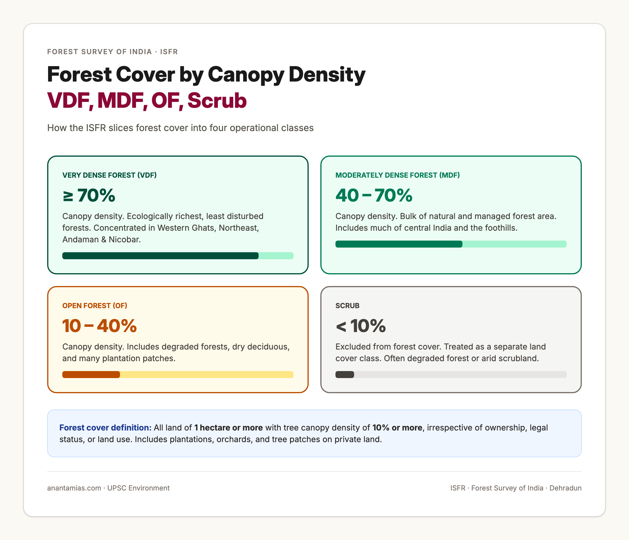
The India State of Forest Report is a biennial assessment of the country’s forest and tree resources. The publishing body is the Forest Survey of India, headquartered at Dehradun. The administrative ministry is the Ministry of Environment, Forest and Climate Change. The methodology combines wall-to-wall remote sensing of the country using satellite data with a sample-based ground inventory called the National Forest Inventory. Forest cover is defined as all land of one hectare or more with tree canopy density of ten percent or more, irrespective of ownership, legal status, or land use. Forest cover is therefore wider than recorded forest area; it includes plantations, orchards, and tree patches outside government forests. The report classifies forest cover by canopy density into Very Dense Forest with canopy density of 70 percent or more, Moderately Dense Forest with canopy density between 40 and 70 percent, and Open Forest with canopy density between 10 and 40 percent. Areas with less than 10 percent canopy density are classified as Scrub. As per ISFR 2023 (released December 2024), the forest and tree cover of the country is 25.17 percent of the geographical area. Forest cover is 21.76 percent and tree cover is 3.41 percent. Top three states in absolute forest area: Madhya Pradesh, Arunachal Pradesh, Maharashtra. Top three states by percentage of geographical area under forest cover: Lakshadweep at 91.33 percent, Mizoram at 85.34 percent, and the Andaman and Nicobar Islands at 81.62 percent. Total mangrove cover is 4,992 square kilometres.
What the India State of Forest Report Is
The India State of Forest Report is best understood as the country’s national forest accounts. It does for forests what the budget does for public finance: a structured, repeatable, comparable record of the resource and how it is changing. The report is published every two years and the time series goes back to 1987, which is when the Forest Survey of India released the first full assessment of forest cover using satellite-based remote sensing. The series is the longest continuous wall-to-wall national forest inventory in the developing world.
ISFR has several volumes. The first volume covers national-level findings, methodology, and thematic chapters such as carbon stock, mangroves, hill and tribal districts, and the impact of climate change on forests. The second volume contains state-by-state and union territory chapters with district-level cover figures and a profile of the major forest types. Subsequent volumes contain detailed tables and the full National Forest Inventory data.
ISFR sits inside a wider data system. The wall-to-wall mapping is complemented by forest fires in India monitoring, by the mangrove forest in India assessments, and by linked legal frameworks such as the Forest Conservation Amendment Act 2023 and the Forest Rights Act 2006. The numbers in ISFR feed into India’s reporting under the United Nations Framework Convention on Climate Change and into the country’s nationally determined contributions on the additional carbon sink target.
Background and Historical Context
The Forest Survey of India was set up in 1981 as a successor to the Pre-investment Survey of Forest Resources. Its initial mandate was to provide reliable inventory data for forest planning and to monitor changes in the country’s forest cover. Until the early 1980s most national figures on forest cover came from departmental records, which often diverged sharply from the actual situation on the ground. With the spread of polar-orbiting earth observation satellites in the 1970s and 1980s, wall-to-wall remote sensing became technically and financially feasible, and the Forest Survey of India released the first State of Forest Report in 1987.
The methodology has gone through three broad generations. In the first generation, satellite imagery was visually interpreted and digitised on a 1:250,000 scale. In the second generation, from the late 1990s, the resolution improved to 1:50,000 with Indian Remote Sensing Satellite data. The current third generation uses high-resolution satellite imagery, geographic information systems, and the National Forest Inventory, which was introduced in the 2002 cycle to add field-level detail to the satellite-based wall-to-wall mapping.
The link between ISFR and policy has tightened over time. The 1988 National Forest Policy set a target of one-third of the country’s geographical area under forest and tree cover; ISFR is the official scorecard for this target. The Compensatory Afforestation Fund Management and Planning Authority, the Green India Mission, the National Mission for a Green India, and the additional carbon sink target under the Paris Agreement all use ISFR as their reference dataset.
Key Definitions That Aspirants Confuse
Forest cover means all land of one hectare or more with a tree canopy density of ten percent or more, irrespective of ownership, legal status, or land use. The definition is land-cover-based rather than land-use-based. A tea garden, an orchard, a coconut plantation, a mango plantation, or even an urban park can qualify as forest cover if it meets the size and canopy thresholds. This is a common stumbling block for aspirants because the popular conception of forest is much narrower.
Tree cover is defined as the cover of trees outside the recorded forest area in patches of less than one hectare. It is essentially the residual category for trees that do not meet the size threshold for forest cover but are still part of the country’s tree resource. Examples include trees on farm bunds, in homesteads, and along roadsides. Tree cover is estimated using a sampling-based methodology rather than wall-to-wall remote sensing because the patches are too small for satellite-based mapping at standard resolution.
Recorded Forest Area, abbreviated as RFA, is the area recorded as forest in government records irrespective of actual tree cover on the ground. RFA is a legal category and includes Reserved Forests, Protected Forests, and Unclassed Forests notified under the Indian Forest Act 1927 or the corresponding state legislations. RFA can be larger than forest cover (when forest land has been degraded) or smaller (when forest cover has expanded into private land or plantations).
Notified Forest is forest area that has been formally declared under a forest law. All Reserved Forests and Protected Forests are notified forest by definition. Unclassed Forests may or may not be notified, depending on state law.
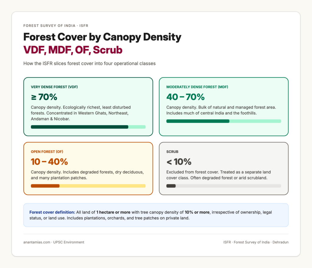
Very Dense Forest, abbreviated as VDF, is forest cover with canopy density of 70 percent or more. VDF represents the ecologically richest forests, mainly concentrated in the Western Ghats, the Northeast, and the Andaman and Nicobar Islands. Moderately Dense Forest, abbreviated as MDF, has canopy density between 40 and 70 percent. Open Forest, abbreviated as OF, has canopy density between 10 and 40 percent. Areas with less than 10 percent canopy density are classified as Scrub and excluded from forest cover.
Methodology of the India State of Forest Report
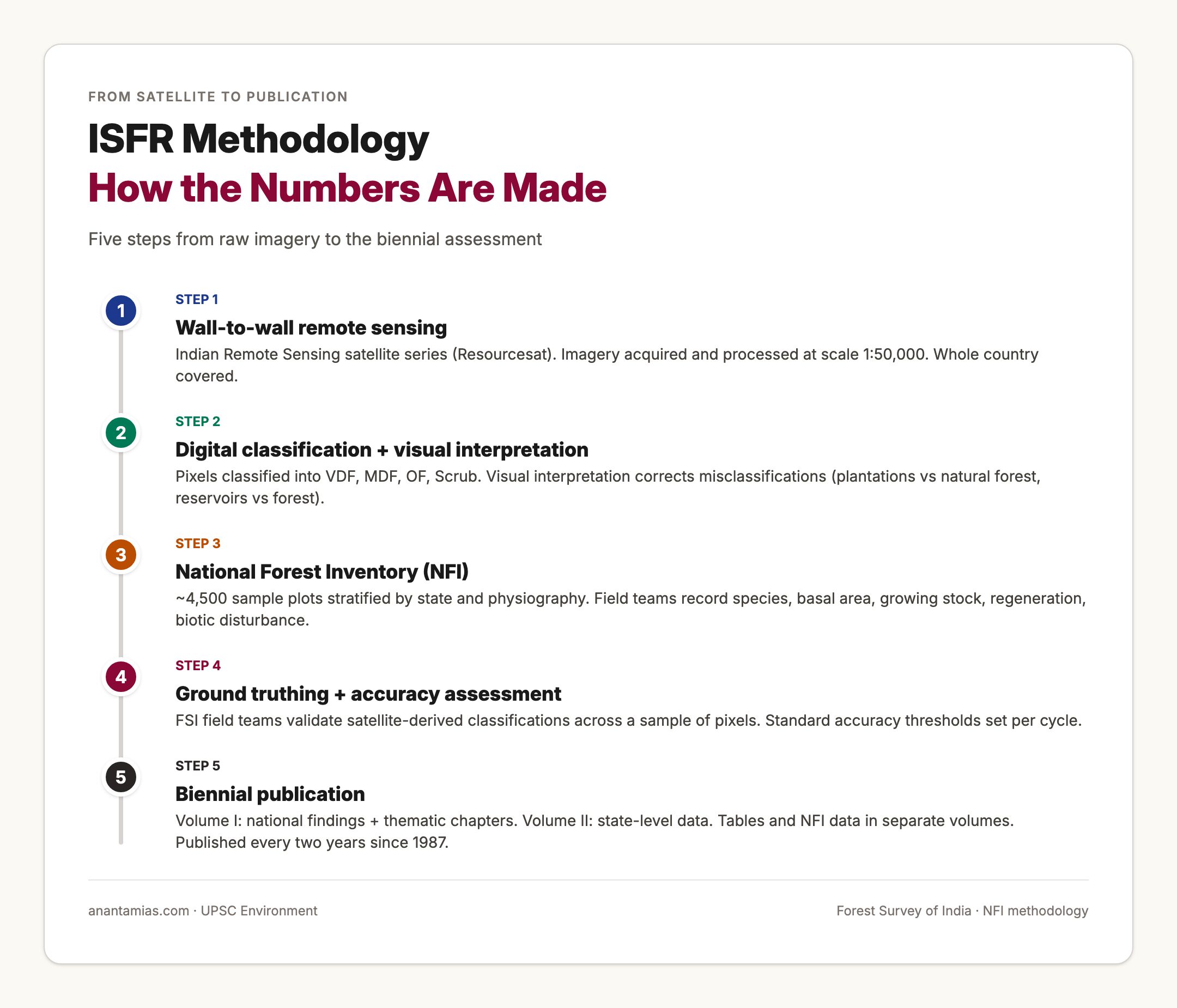
The methodology has three pillars: wall-to-wall satellite mapping, the National Forest Inventory, and quality assurance through ground truthing.
The satellite mapping uses data from the Indian Remote Sensing satellite series, particularly Resourcesat. The data is processed at a scale of 1:50,000. Digital classification is followed by visual interpretation to correct misclassifications, which is essential because some plantations and reservoirs can be confused with natural forest by automated classifiers alone. Each pixel is classified into one of the canopy density classes, and contiguous pixels are aggregated into the one-hectare minimum mapping unit.
The National Forest Inventory adds depth. Around 4,500 sample plots are surveyed across the country in each two-year cycle. The plots are stratified by state and by physiography. In each plot, the field team records data on tree species composition, basal area, growing stock, height, regeneration, soil characteristics, signs of human disturbance, and biotic pressure. The inventory data feed into estimates of growing stock, carbon stock, and biodiversity indicators that the wall-to-wall mapping cannot produce on its own.
Ground truthing is the third pillar. The Forest Survey of India deploys field teams to validate satellite-derived classifications across a sample of pixels. Validation is essential for the credibility of canopy density estimates because canopy density classes blur into each other along the boundaries.
Why the India State of Forest Report Matters
The report matters because forests are the single largest natural land cover type in India and one of the largest stores of biodiversity and carbon. Three lines of policy depend directly on ISFR.
First, forest policy. The 1988 National Forest Policy set a target of 33 percent of the country’s geographical area under forest and tree cover. The 25.17 percent figure in the latest assessment, broken into 21.76 percent forest cover and 3.41 percent tree cover, shows the country is still meaningfully below the target despite four decades of policy effort. The biennial cycle lets the policy community track progress and identify states that are pulling the average up or down.
Second, climate policy. India has committed to creating an additional carbon sink of 2.5 to 3 billion tonnes of carbon dioxide equivalent through forest and tree cover by 2030 under its Paris nationally determined contributions. The carbon stock estimates in ISFR are the official measurement system for this commitment.
Third, conservation and tribal policy. ISFR data is used to identify zones for conservation reserves, biosphere reserves, and tiger reserves; to monitor mangrove and wetland health; and to track the effectiveness of community forest rights granted under the Forest Rights Act.
Detailed Findings of the Latest Assessment
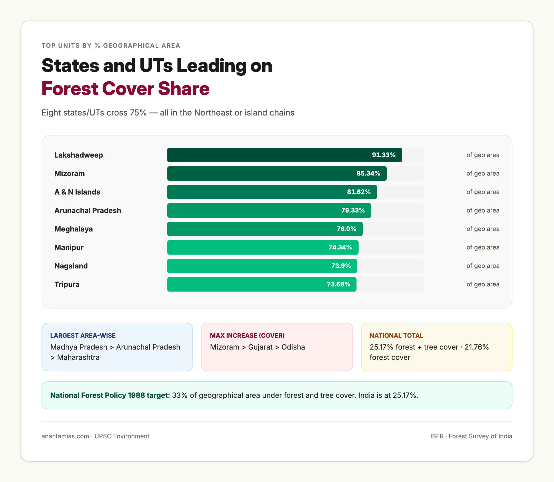
The total forest and tree cover of the country is 25.17 percent of the geographical area, broken into 21.76 percent forest cover and 3.41 percent tree cover. The top four states showing maximum increase in combined forest and tree cover are Chhattisgarh, Uttar Pradesh, Odisha, and Rajasthan in that order. The top three states showing the maximum increase in forest cover alone are Mizoram, Gujarat, and Odisha. In absolute area terms the top three states are Madhya Pradesh, Arunachal Pradesh, and Maharashtra. The top three units by percentage of geographical area under forest cover are Lakshadweep at 91.33 percent, Mizoram at 85.34 percent, and the Andaman and Nicobar Islands at 81.62 percent.
Nineteen states and union territories have above 33 percent of their geographical area under forest cover, meaning they meet or exceed the National Forest Policy target. Of these, eight have forest cover above 75 percent: Mizoram, Lakshadweep, Andaman and Nicobar Islands, Arunachal Pradesh, Nagaland, Meghalaya, Tripura, and Manipur. The Northeastern states therefore continue to dominate the high-cover end of the distribution.
The total mangrove cover is 4,992 square kilometres. The Sundarbans in West Bengal account for the largest share, followed by Gujarat and the Andaman and Nicobar Islands. Mangrove cover is monitored separately because of its ecological and disaster-mitigation value.
The bamboo bearing area has increased compared to the previous assessment. Bamboo is monitored under a separate methodology because the canopy structure of bamboo differs from broadleaf forests. There is also an increase in the country’s carbon stock as compared to the last assessment, which reflects both the slight expansion of forest cover and the maturing of plantation forests.
Comparative: Forest Cover vs Recorded Forest Area
Forest cover and recorded forest area answer two different questions. Forest cover answers the land-cover question: how much land actually has tree canopy. Recorded forest area answers the legal question: how much land is recorded as forest in government records. The two diverge in two directions.
Forest cover can exceed recorded forest area when plantations, orchards, and private forests have grown beyond the boundaries of legally notified forest land. Recorded forest area can exceed forest cover when notified forest land has been degraded or encroached on, leaving little tree canopy on the ground. Both situations exist across India. The difference between the two is the most useful operational lens for understanding the gap between de jure and de facto forest in any given state.
Challenges and Critiques
ISFR has been criticised on several fronts. The first is the wide forest cover definition. Including plantations of one hectare and above with ten percent canopy density means that homogeneous monoculture plantations, including commercial plantations of teak, eucalyptus, rubber, and even coffee under shade, count toward the headline figure. Critics argue that this overstates the country’s forest health because biodiversity in monoculture plantations is far lower than in natural forests of equivalent canopy density.
The second critique focuses on canopy density thresholds. The minimum 10 percent canopy density threshold is permissive by international standards, where 30 percent is more common in some inventories. Adjusting for canopy density would lower the headline figure but tighten its meaning.
The third critique is data lag. ISFR is biennial, which is a global best practice, but the cycle from data acquisition to publication can run 18 to 24 months. For policy questions on rapid land-use change, more frequent updates would be useful.
The fourth critique is regional. The Northeast has seen substantial loss in some states even as the headline cover remains high. The aggregate figures can mask localised loss.
Prelims Pointers
The India State of Forest Report is published biennially by the Forest Survey of India under the Ministry of Environment, Forest and Climate Change.
Forest cover means land of one hectare or more with canopy density of 10 percent or more, irrespective of ownership.
Canopy density classes: VDF is at least 70 percent, MDF is 40 to 70 percent, OF is 10 to 40 percent, Scrub is less than 10 percent.
Top three states by area: Madhya Pradesh, Arunachal Pradesh, Maharashtra.
Top three by percentage: Lakshadweep, Mizoram, Andaman and Nicobar Islands.
Total mangrove cover is 4,992 square kilometres. Forest and tree cover combined is 25.17 percent of geographical area.
Eight states or union territories have forest cover above 75 percent: Mizoram, Lakshadweep, A&N Islands, Arunachal Pradesh, Nagaland, Meghalaya, Tripura, Manipur.
Mains Questions
Discuss the methodology of the India State of Forest Report and assess whether the existing definition of forest cover overstates the country’s forest health. (GS III, 250 words)
The 1988 National Forest Policy targets 33 percent of the geographical area under forest and tree cover. Evaluate India’s progress toward this target using the latest India State of Forest Report. (GS III, 250 words)
Examine the role of the India State of Forest Report in supporting India’s commitments under the Paris Agreement and the United Nations Framework Convention on Climate Change. (GS III, 150 words)
Forest cover and recorded forest area can diverge significantly across Indian states. Explain the reasons for this divergence and discuss its implications for forest governance. (GS III, 250 words)
Way Forward
The way forward has three priorities. The first is to publish disaggregated data on plantations and natural forests separately within ISFR so that analysts can read the headline number with the appropriate caveats. The second is to integrate the ISFR data layers with the Forest Rights Act community forest resource maps, with the wildlife sanctuary and national park boundaries, and with state revenue records, so that policy users can run intersection queries that the present scattered data publication does not allow. The third is to expand the National Forest Inventory sample density in regions undergoing rapid land-use change, particularly in the Northeast and along the central Indian forest belt, so that the sample-based growing stock and carbon stock estimates are tight enough to support landscape-level interventions.
Frequently Asked Questions
What is the India State of Forest Report?
The India State of Forest Report, abbreviated as ISFR, is the biennial official assessment of the country’s forest and tree resources. It is published by the Forest Survey of India, the technical wing of the Ministry of Environment, Forest and Climate Change, and is the country’s most authoritative source on forest cover, tree cover, growing stock, carbon stock, and mangrove cover.
Which body publishes the India State of Forest Report?
The India State of Forest Report is published by the Forest Survey of India, headquartered at Dehradun in Uttarakhand. The Forest Survey of India is an autonomous organisation under the Ministry of Environment, Forest and Climate Change.
How is forest cover defined in the India State of Forest Report?
Forest cover is defined as all land of one hectare or more with a tree canopy density of ten percent or more, irrespective of ownership, legal status, or land use. The definition is land-cover-based rather than land-use-based, and includes plantations, orchards, and tree patches on private land that meet the canopy and area thresholds.
What is the difference between forest cover and recorded forest area?
Forest cover refers to actual tree canopy on the ground meeting the threshold definition, while recorded forest area is the area recorded in government records as forest under the Indian Forest Act 1927 or state forest laws. The two figures can diverge: forest cover can exceed recorded forest area when private plantations grow beyond legal forest land, and recorded forest area can exceed forest cover when notified forest land has been degraded.
What are the canopy density categories used in the India State of Forest Report?
The categories are Very Dense Forest with canopy density of 70 percent or more, Moderately Dense Forest with canopy density between 40 and 70 percent, Open Forest with canopy density between 10 and 40 percent, and Scrub with canopy density less than 10 percent.
Which Indian states have the highest forest cover?
In absolute area terms the top three states are Madhya Pradesh, Arunachal Pradesh, and Maharashtra. In terms of percentage of geographical area under forest cover, the top three units are Lakshadweep at 91.33 percent, Mizoram at 85.34 percent, and the Andaman and Nicobar Islands at 81.62 percent.
What is India’s national target for forest and tree cover?
The 1988 National Forest Policy set a target of one-third of the country’s geographical area under forest and tree cover. As per the latest assessment, the combined forest and tree cover is 25.17 percent of the geographical area, comprising 21.76 percent forest cover and 3.41 percent tree cover.
How is the India State of Forest Report prepared?
The methodology combines wall-to-wall remote sensing using Indian Remote Sensing satellite data interpreted at a scale of 1:50,000 with a sample-based National Forest Inventory of around 4,500 plots that captures field-level data on species composition, growing stock, regeneration, and biotic disturbance. Quality assurance is provided through systematic ground truthing.
Why is the India State of Forest Report important for climate policy?
The carbon stock estimates published in the report are the official measurement system for India’s commitment to create an additional carbon sink of 2.5 to 3 billion tonnes of carbon dioxide equivalent through forest and tree cover by 2030 under the Paris nationally determined contributions.
How often is the India State of Forest Report published?
The India State of Forest Report is published biennially, that is, once every two years. The time series goes back to the first assessment in 1987.
Tell Google you want more of this.
Add Anantam IAS as a preferred sourceOne tap, and this site shows up more often in your own Top Stories, AI Overviews and AI Mode. Remove it any time.