

The India Meteorological Department, usually called IMD, is the country’s national agency for weather, climate, and seismology. Every monsoon update on the news, every cyclone bulletin that triggers a coastal evacuation, every farmer advisory that tells a Marathwada cotton grower whether to delay sowing, and every seismic alert after a Himalayan tremor traces back to a single institution headquartered at Mausam Bhavan in New Delhi. IMD is not just a weather office. It is a regulatory and advisory body that sits at the intersection of disaster management, agriculture, aviation, defence, and climate science.
For UPSC GS-III, IMD shows up across multiple fronts. It is the operational core of India’s disaster preparedness for hydro-meteorological hazards, the climate data backbone for the Indian Council of Agricultural Research’s crop advisories, the regional cyclone authority for the entire North Indian Ocean basin, and a frequent prelims question on its parent ministry, founding year, and key functions. The department also features in mains questions on monsoon forecasting, climate adaptation, and the institutional response to extreme weather events.
This guide walks through IMD’s history, its current mandate under the Ministry of Earth Sciences, the observation network it runs, the forecast products it issues, its RSMC role under the World Meteorological Organisation, and the recent reforms that are reshaping how the department delivers warnings to last-mile users.
Quick Facts
- Established: 1875, in Calcutta (now Kolkata)
- Headquarters: Mausam Bhavan, New Delhi (since 1944)
- Parent ministry: Ministry of Earth Sciences (MoES)
- Head: Director General of Meteorology
- Founding charter: Imperial Meteorological Department, set up after the Great Calcutta Cyclone of 1864 and the Bengal famine of 1866-67
- Regional role: Regional Specialized Meteorological Centre (RSMC) for the North Indian Ocean under the World Meteorological Organisation (WMO)
- Cyclone naming: IMD coordinates cyclone naming for 13 countries in the North Indian Ocean basin
- Observation network: Over 800 surface observatories, 39 Doppler weather radars, satellites (INSAT-3D, INSAT-3DR), automatic weather stations, upper-air sounding stations
- Operational forecast horizons: Nowcast (3 hours), short-range (1-3 days), medium-range (4-10 days), extended range (10-30 days), seasonal (entire monsoon)
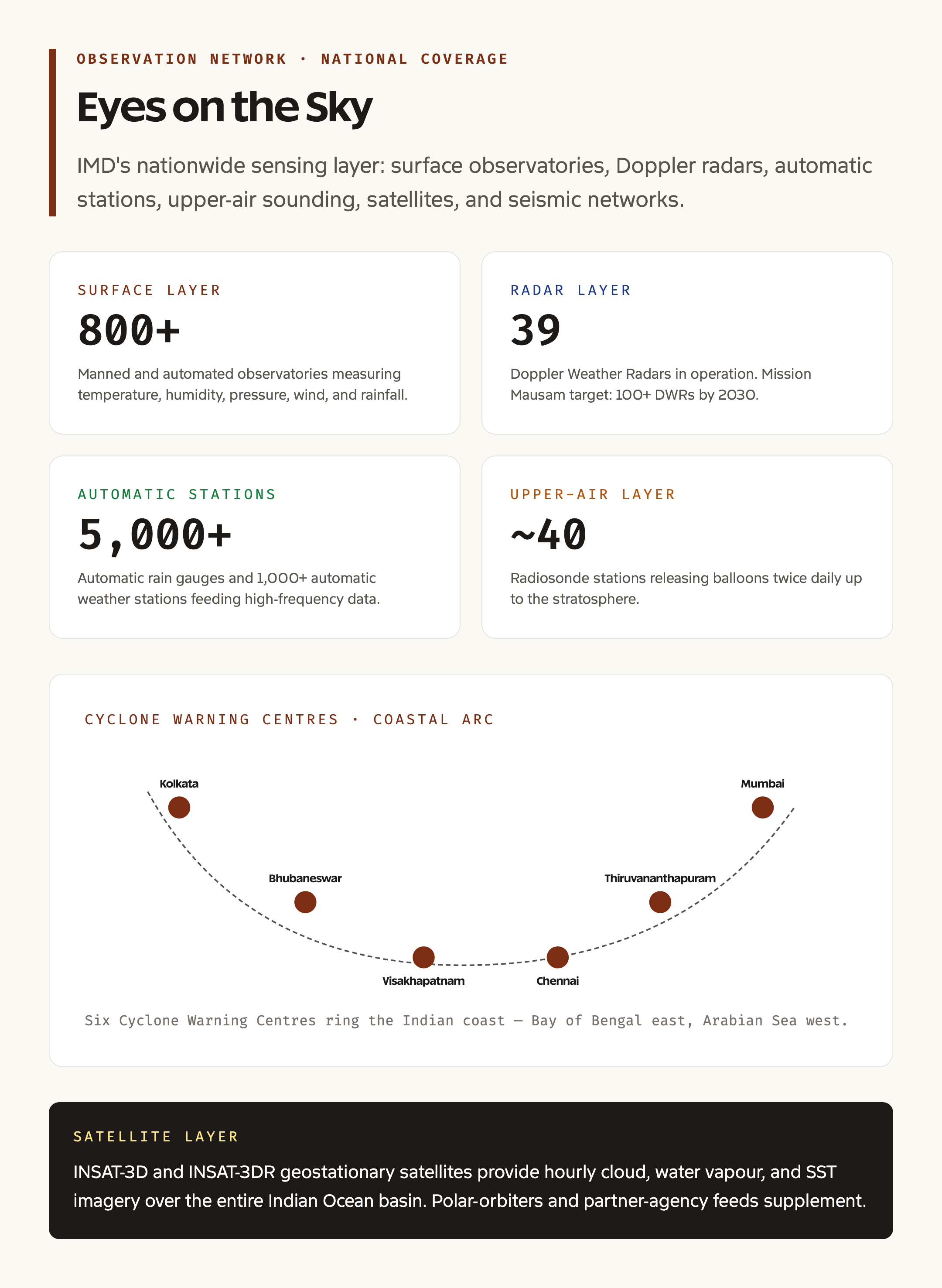
- Cyclone warning units: Six Cyclone Warning Centres at Kolkata, Bhubaneswar, Visakhapatnam, Chennai, Thiruvananthapuram, and Mumbai
- Statutory backbone: Indian Meteorological Department is a subordinate office of MoES, not an independent statutory body
What IMD Does
The simplest way to understand IMD is to think of it as a public utility for atmospheric and seismic information. The department collects raw observations from a vast sensor network spread across the subcontinent and the surrounding oceans, runs numerical weather prediction models on its high-performance computing systems, and pushes out forecasts and warnings through bulletins, mobile apps, broadcast media, and direct lines to disaster management authorities.
The department’s products reach four main user groups. The general public receives daily forecasts and severe weather warnings through the Mausam app, the IMD website, and partner broadcast channels. Farmers receive block-level agromet advisories twice a week through the Gramin Krishi Mausam Sewa, distributed via Kisan Call Centres, mobile messaging, and the Meghdoot app. Aviation operators receive specialised meteorological information through the IMD aviation services unit at major airports. Disaster management authorities at the national, state, and district levels receive cyclone, heavy rainfall, heatwave, cold wave, and thunderstorm warnings, often hours to days before the event reaches the ground.
Background and Historical Context
IMD’s origin is rooted in two colonial-era disasters. The Great Calcutta Cyclone of October 1864 killed around 60,000 people in the Bay of Bengal coast and destroyed shipping in Calcutta port. Two years later, the failure of the southwest monsoon led to the Orissa famine of 1866 and the wider Bengal famine of 1866-67. The British administration, prompted by the cost of these events to revenue and trade, decided that systematic meteorological observation was essential. The Imperial Meteorological Department was established by Government of India order in 1875, initially based in Calcutta with Henry Francis Blanford as the first Imperial Meteorological Reporter.
The headquarters moved to Shimla in 1905, then to Pune in 1928, and finally to New Delhi in 1944. After independence, IMD continued under the Ministry of Communications, then Defence, then Civil Aviation, before being shifted to the newly created Ministry of Earth Sciences in 2006. The MoES move was significant because it brought IMD into the same administrative family as the Indian National Centre for Ocean Information Services (INCOIS), the National Centre for Medium Range Weather Forecasting (NCMRWF), and the Indian Institute of Tropical Meteorology (IITM), creating an integrated earth-system science cluster.
Organisational Structure
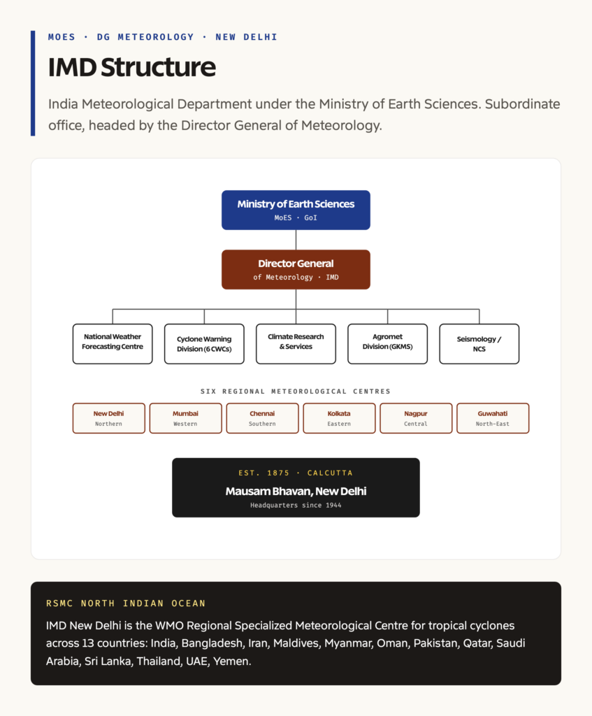
IMD is a subordinate office under the Ministry of Earth Sciences. The Director General of Meteorology heads the department and reports to the Secretary, MoES. Under the Director General, the structure splits into operational divisions and regional offices.
The operational divisions handle specialised functions. The National Weather Forecasting Centre runs daily forecasting operations. The Cyclone Warning Division operates the six Cyclone Warning Centres along the coast. The Climate Research and Services unit produces monsoon outlooks and climate assessments. The Hydrology Division coordinates with the Central Water Commission on flood forecasting. The Agricultural Meteorology Division manages the agromet advisory service. The Seismology Division operates the National Centre for Seismology, which monitors earthquakes across India and adjoining regions.
The regional structure splits the country into six Regional Meteorological Centres, located at New Delhi (Northern), Mumbai (Western), Chennai (Southern), Kolkata (Eastern), Nagpur (Central), and Guwahati (North-Eastern). Each Regional Centre supervises a network of state-level Meteorological Centres, which in turn supervise the surface observatories, agromet field units, and Doppler weather radars in their territory.
Observation Network
The forecast quality depends entirely on the input data, and IMD has built one of the largest weather observation networks in the developing world. The network has several layers.
The surface observatory layer has over 800 manned and automated stations measuring temperature, humidity, pressure, wind, and rainfall at hourly or three-hourly intervals. About 5,000 automatic rain gauges and over 1,000 automatic weather stations supplement the manned network with high-frequency data feeds. Above the surface, around 40 upper-air observation stations release radiosondes twice a day to measure wind, temperature, and humidity profiles up to the stratosphere.
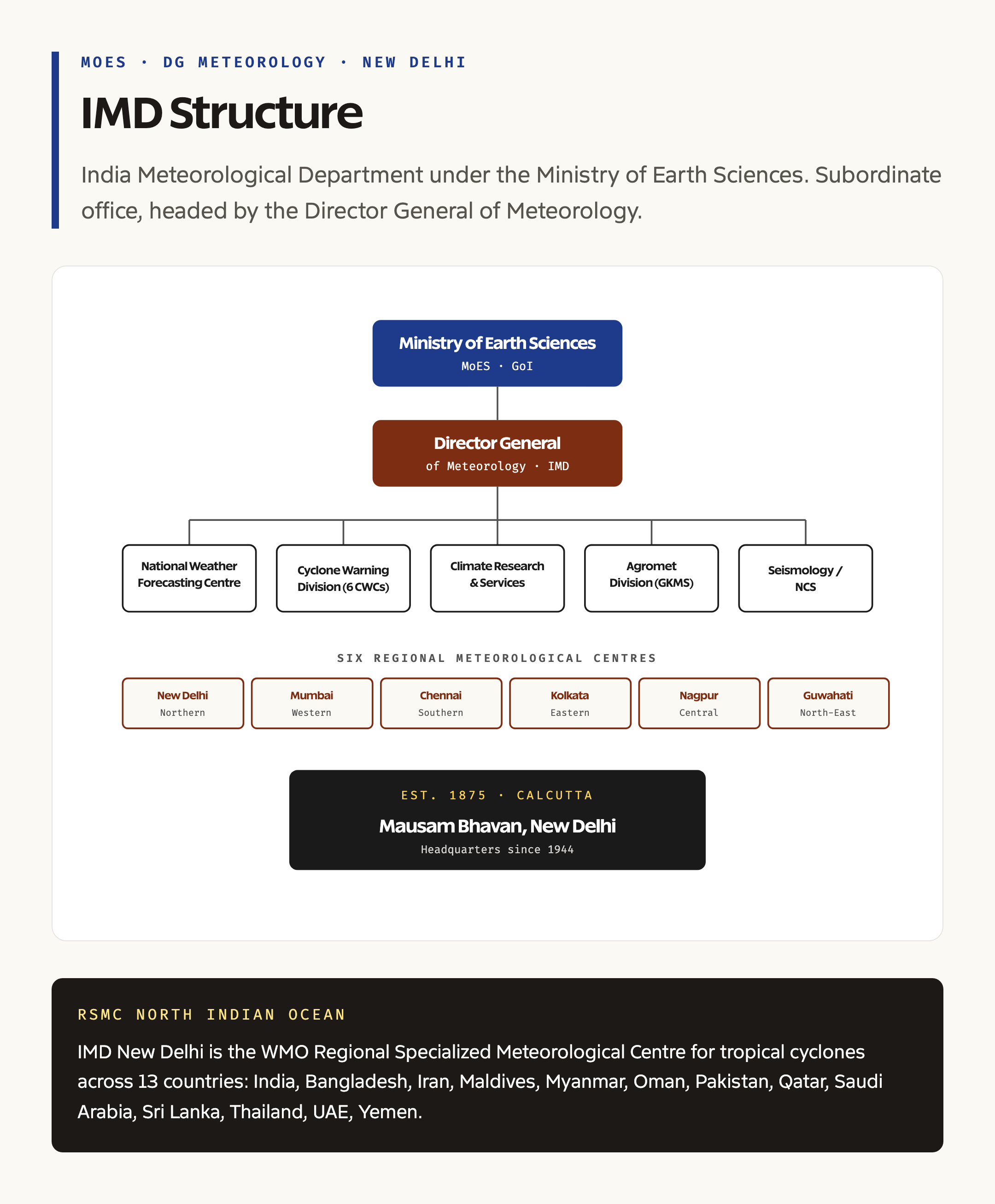
The radar layer is the backbone of severe weather monitoring. The country now has 39 Doppler Weather Radars (DWRs), with a target of 70-plus over the coming years. DWRs detect rainfall intensity, wind shear, and storm rotation in a 250-kilometre radius and refresh every 10 minutes, which is what makes nowcasting of thunderstorms and cyclone landfall possible.
The satellite layer relies primarily on the INSAT-3D and INSAT-3DR geostationary satellites operated by ISRO and configured for IMD’s meteorological imaging needs. These provide hourly cloud, water vapour, and sea surface temperature imagery over the entire Indian Ocean basin. The satellites are supplemented by polar-orbiting platforms and data exchange agreements with other space agencies.
The seismic layer is operated by the National Centre for Seismology and includes around 150 seismic stations distributed across India. The network detects and locates earthquakes within minutes and feeds the data into the National Disaster Management Authority’s response system.
Forecast Products
IMD issues forecasts at multiple temporal scales, each serving a different decision-maker.
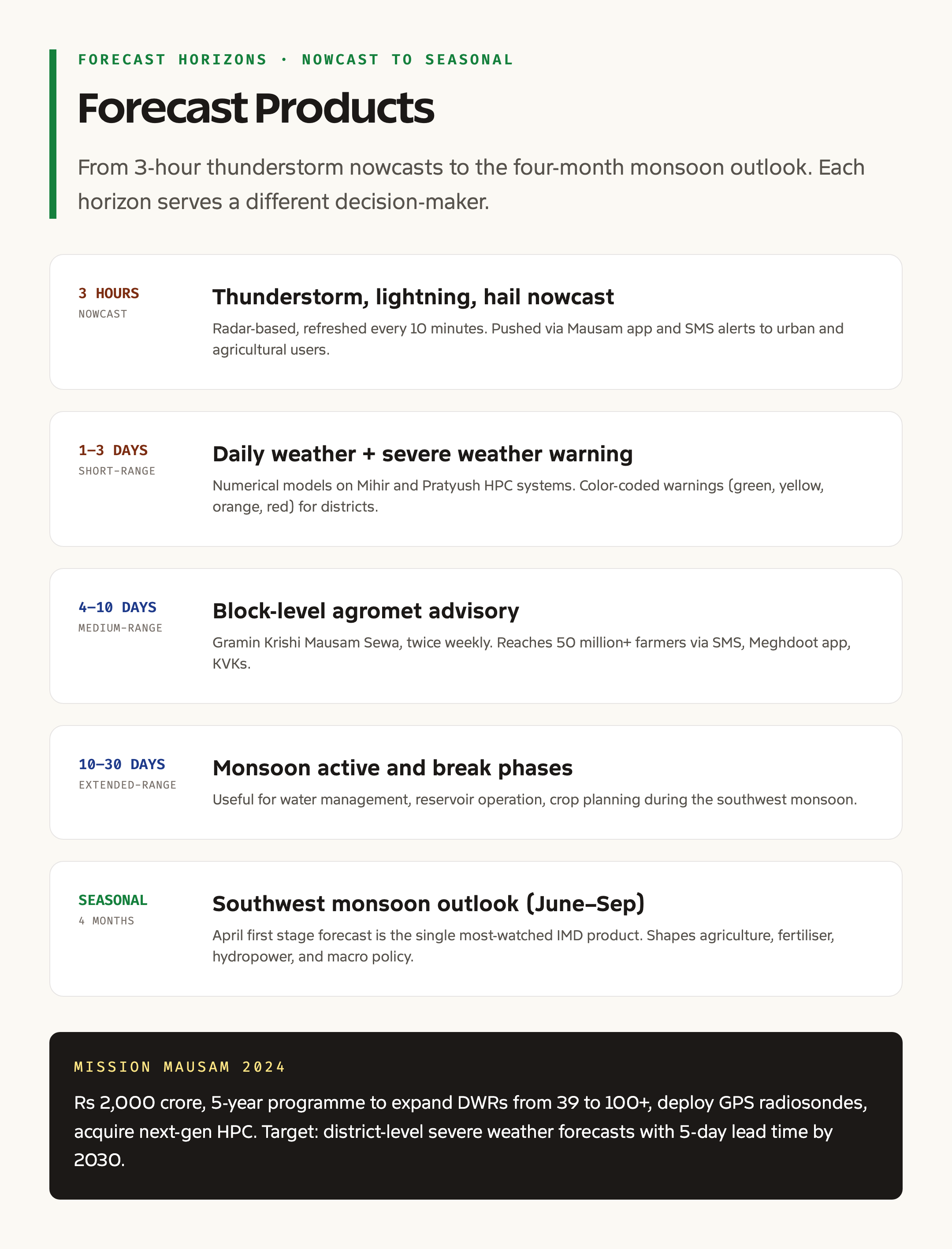
Nowcasts cover the next 3 hours and focus on thunderstorms, lightning, hailstorms, and intense rainfall over urban and agricultural areas. They are issued by the radar-based Now Casting unit at IMD Pune and disseminated through mobile apps and SMS alerts.
Short-range forecasts cover 1 to 3 days and form the bread-and-butter daily weather product. The forecasts are produced using global and regional numerical models running on IMD’s Mihir and Pratyush high-performance computing systems.
Medium-range forecasts cover 4 to 10 days and are particularly important for agriculture. The Gramin Krishi Mausam Sewa pushes block-level medium-range agromet advisories to over 50 million farmers through SMS, mobile apps, and Krishi Vigyan Kendras.
Extended-range forecasts cover 10 to 30 days and capture monsoon active and break phases, useful for water management and crop planning. Seasonal forecasts cover the entire southwest monsoon (June to September) and the northeast monsoon (October to December). The April southwest monsoon forecast is the single most-watched IMD product of the year, since it shapes expectations across agriculture, fertiliser dispatch, hydropower, and macro-economic policy.
Cyclone Warning System
IMD is the cyclone authority for the North Indian Ocean basin, which covers the Bay of Bengal and the Arabian Sea. Under the World Meteorological Organisation, IMD New Delhi is the Regional Specialized Meteorological Centre (RSMC) for tropical cyclones in this basin and issues forecasts and warnings to all 13 member countries: India, Bangladesh, Iran, Maldives, Myanmar, Oman, Pakistan, Qatar, Saudi Arabia, Sri Lanka, Thailand, the United Arab Emirates, and Yemen.
The cyclone warning has a four-stage structure: pre-cyclone watch (72 hours before landfall), cyclone alert (48 hours), cyclone warning (24 hours), and post-landfall outlook. The classification follows the WMO scheme, ranging from depression to super cyclonic storm based on three-minute sustained surface wind speed.
Cyclone names follow a rotating list contributed by all 13 RSMC members. India’s contributions include names like Tej, Gati, Aag, Vyom, Jhar, Probaho, and Neer. The naming system was introduced in 2004 to make warnings more memorable and to standardise cross-border communication.
Agromet and Last-Mile Services
The Gramin Krishi Mausam Sewa is one of IMD’s most operationally consequential products. The service produces district and block-level weather forecasts twice a week (Tuesday and Friday) for the next five days, packages them with crop-specific advisories from Krishi Vigyan Kendras, and delivers them through SMS, mobile apps, WhatsApp, broadcast media, and Common Service Centres.
A 2023 study by the National Council of Applied Economic Research estimated that block-level agromet advisories save Indian agriculture around Rs 13,000 crore a year through avoided sowing losses, optimised fertiliser timing, and reduced pesticide spraying in unsuitable weather. The Meghdoot mobile app, launched in 2019 with the Indian Council of Agricultural Research, delivers the same advisories directly to farmer phones in regional languages.
Seismic Monitoring
The National Centre for Seismology, an attached unit of IMD, runs the country’s earthquake monitoring network. The centre maintains around 150 broadband seismic stations and operates a 24-hour earthquake monitoring centre at New Delhi. Earthquake detection, location, and magnitude estimation are completed within 5 to 10 minutes of an event, and the information is pushed to the National Disaster Management Authority and state disaster management authorities for response coordination.
The centre also conducts seismic microzonation studies for major Indian cities, hosts the Indian seismograph network, and represents India in international seismological data-exchange protocols.
Recent Reforms and Mission Mausam
In 2024, the Union Cabinet approved Mission Mausam, a five-year programme with a Rs 2,000 crore outlay aimed at substantially upgrading IMD’s observation and forecasting capabilities. The mission has three pillars: expanding the radar network from 39 to over 100 DWRs, deploying GPS-based radiosondes at all upper-air stations, and acquiring next-generation high-performance computing systems for finer-resolution numerical models. The target is district-level severe weather forecasts with five-day lead times by 2030.
IMD has also been expanding its impact-based forecasting system. Traditional forecasts say what the weather will do (for example, 200 mm of rain in 24 hours). Impact-based forecasts say what the weather will cause (for example, urban flooding in low-lying areas of Mumbai). The shift requires integrating IMD data with hydrological models, urban infrastructure data, and population vulnerability maps, which is being done through partnerships with the National Disaster Management Authority and state agencies.
Mains Hooks and Prelims Pegs
For prelims, the high-frequency facts are IMD’s founding year (1875), parent ministry (MoES), headquarters (New Delhi), RSMC role for North Indian Ocean, and the cyclone naming protocol. UPSC has also asked about the Gramin Krishi Mausam Sewa and the Meghdoot app in recent papers.
For mains, IMD fits naturally into questions on disaster management (cyclone preparedness on the east coast), agricultural resilience (agromet advisories), climate adaptation (heatwave and cold wave warnings), and institutional reforms (Mission Mausam, integration with NDMA). A useful framing is that IMD is the data-and-warning institution while NDMA is the response institution, and the two operate through structured information-sharing protocols built up after Cyclone Phailin (2013) and reinforced after each major event since.
Frequently Asked Questions
What is the India Meteorological Department?
IMD is India’s national agency for weather, climate, and seismological services. It is a subordinate office under the Ministry of Earth Sciences, headquartered at Mausam Bhavan in New Delhi, and was established in 1875.
Under which ministry does IMD function?
IMD functions under the Ministry of Earth Sciences (MoES). It was moved to MoES in 2006 from the Ministry of Civil Aviation. MoES also houses INCOIS, NCMRWF, and IITM.
What is RSMC and what is IMD’s role?
RSMC stands for Regional Specialized Meteorological Centre, a designation by the World Meteorological Organisation. IMD New Delhi is the RSMC for tropical cyclones in the North Indian Ocean basin, issuing forecasts and warnings to 13 member countries including India, Bangladesh, Sri Lanka, and the Gulf states.
How does IMD deliver forecasts to farmers?
Through the Gramin Krishi Mausam Sewa, IMD issues block-level agromet advisories twice a week, packaged with crop-specific guidance from Krishi Vigyan Kendras. Delivery is through SMS, the Meghdoot mobile app, broadcast media, and Common Service Centres.
What is Mission Mausam?
Mission Mausam is a Rs 2,000 crore, five-year programme approved by the Union Cabinet in 2024 to upgrade IMD’s radar network from 39 to over 100 Doppler Weather Radars, deploy GPS radiosondes, and acquire next-generation supercomputers for high-resolution forecasting by 2030.
Tell Google you want more of this.
Add Anantam IAS as a preferred sourceOne tap, and this site shows up more often in your own Top Stories, AI Overviews and AI Mode. Remove it any time.






